Mapping tomorrow’s weather with Big Data
When Europe needed to turn satellite data into the weather products of tomorrow, Thales stepped up with a Big Data solution.
Founded in 1986, EUMETSAT is a European organisation that now serves a total of 30 member states. Its role is to supply weather and climate-related satellite data, images and products to the national meteorological services of its member and cooperating states in Europe, and other users worldwide. To do this, EUMETSAT operates a whole range of Earth-observation satellites. Its latest programme, Meteosat Third Generation (MTG), is based on a twin satellite concept with two types of sensors: imagers, which photograph the Earth from space, and sounders, which analyse the various layers of the atmosphere. Data is used by national weather agencies to make forecasts, perform detailed climate monitoring and analyse specific geographic areas of interest as required. It is also used for research into climate-environment interactions, particularly as part of Europe’s Copernicus programme.
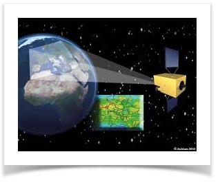
Under a contract running from 2015 to 2021, Thales is helping EUMETSAT develop a ground-based software system that uses complex algorithms to transform huge volumes of raw data into geophysical products and values that can be used directly by the scientific community. The project is built around a software component called Phoebus, which Thales developed for CNES, the French space agency. Phoebus is a universal processing framework offering the massive capacity needed for Big Data applications. For the EUMETSAT project, Thales developed a set of algorithm-based instrument processing chains and software specifications, then integrated these into the previous component after functional and scientific validation.
The Thales system reconstructs the raw data and performs first-level analysis. Its primary benefit is its processing power — the system is 35 times faster than the previous version, producing 7 GB of data every 10 minutes. With this new technology, a greater amount of usable information can be generated in a given timeframe, with a greater degree of precision, so the system can provide map products with real added value.
Fast facts
-
Processing power 35 times faster than the previous system
-
7 GB of data produced every 10 minutes
-
Number of usable images up from 25 to 1,000+ a day in 5 years